TO VISIT
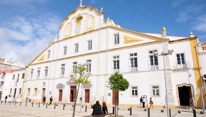
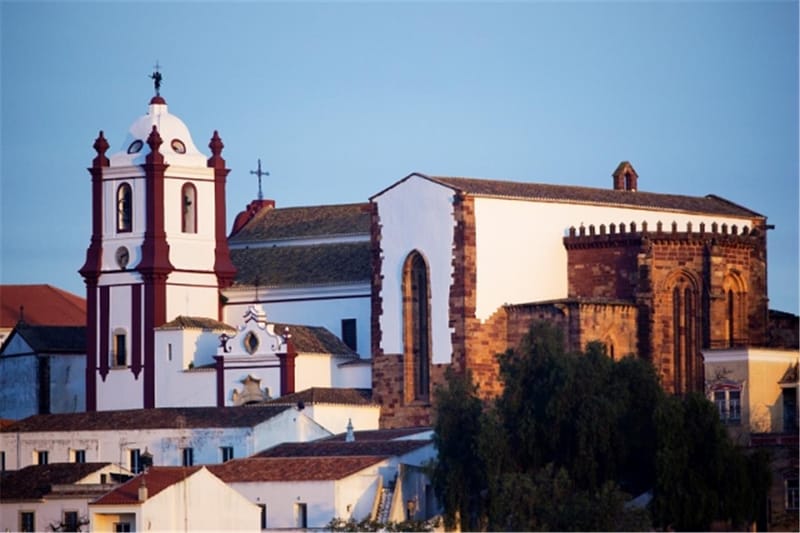
Jesuit College Church
In the Alameda da Praça da República, in Portimão stands the Jesuit Church and College, built at the end of the 19th century. XVII Location: Praça da República 25, 8500-594 Portimão Opening hours: Monday to Friday, from 8:00 am to 12:30 pm and from 3:00 pm to 6:00 pm. Google Maps.: 37.139339, -8.537358
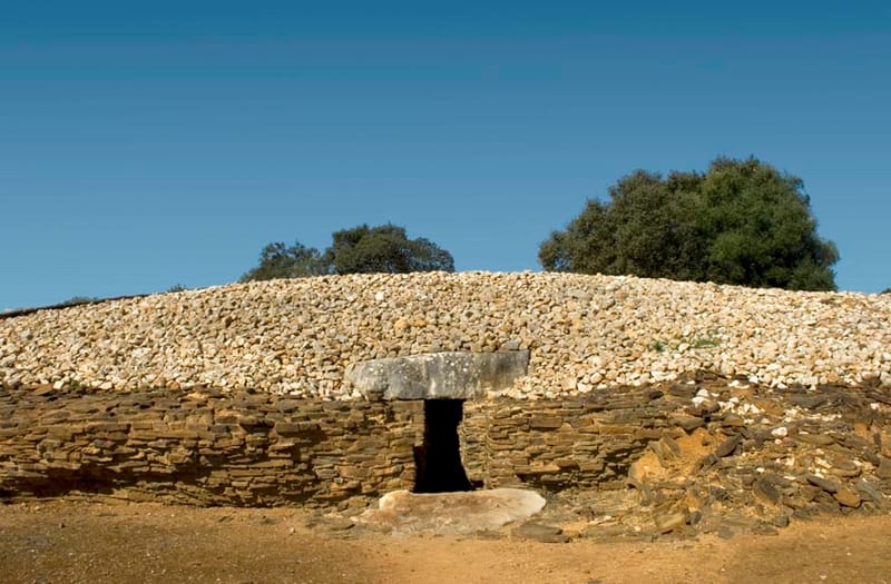
Neolithic settlement of Alcalar
The Neolithic settlement of Alcalar was located on the edge of the formerly navigable section of the Ribeira da Torre, which stretched over a prominent hill, next to Alcalar, about five kilometers from Mexilhoeira Grande, in the heart of the Barrocal Algarve. Arriving at: National Monument – the Megalithic Necropolis of Alcalar – the Interpretation Center allows you to obtain information about the town and the necropolis, as well as to make a socio-cultural and historical framework of this millennial community. Google Maps.: 37.197877, -8.588954
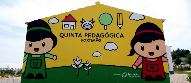
Portimão Pedagogical Farm
The Quinta Pedagógica de Portimão is a municipal facility whose mission is to promote environmental education and awareness and appreciation of the rural world. It occupies an area of around 2 hectares divided into different areas. It has shelters for animals and fruit and vegetable areas and gardens. Quinta Pedagógica de Portimão offers, throughout the year, a diverse set of activities for different audiences. Winter Hours 16/09 to 30/06 Monday to Saturday 9:30 am to 5:30 pm Closed on Sundays and public holidays Summer Hours 01/07 to 15/09 Monday to Friday 9:30 am to 5:30 pm Closed on Saturdays, Sundays and public holidays Contact us ! Rua David Gonçalves Vieira Aldeia Nova da Boavista, 8500-301 Portimão Tel: 282 248 595 | E-mail:quinta.pedagogica@cm-portimao.pt Google Maps.: 37.149762, -8.553199
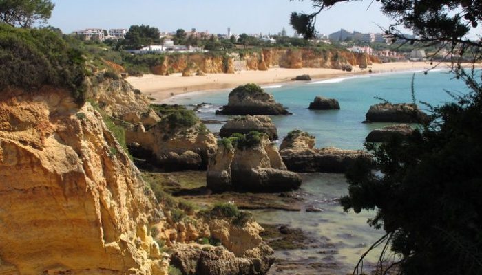
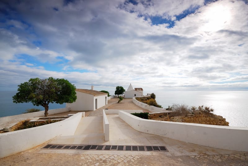
Balconies Over the Sea
This Balconies over the Sea itinerary runs along the most spectacular section of rocky coastline in Portimão, along the top of a cliff made up of Mioconic limestone rocks (23 to 5 million years old). Google Maps.: 37.120327, -8.558980
Learn More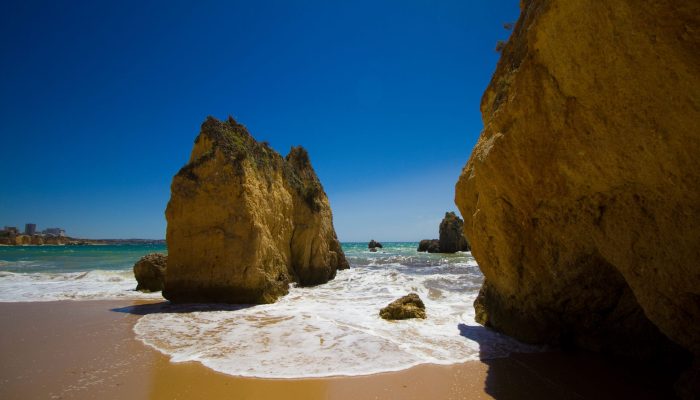
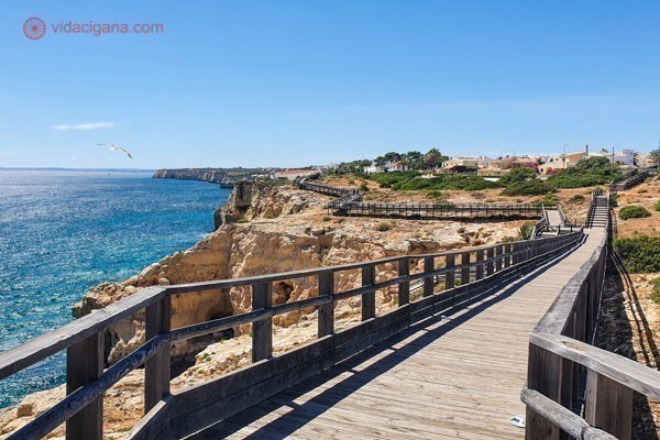
Walk from Praia da Rocha - Praia do Alemão
During low tide you can walk between Praia da Rocha and Praia do Alemão along the sand. On this walk from Praia da Rocha to Praia do Alemão, which can start next to the pier at Praia da Rocha, or at Praia do Alemão, there are constant cliffs with beautiful hues Google Maps.: 37.116037, -8.529486
Learn More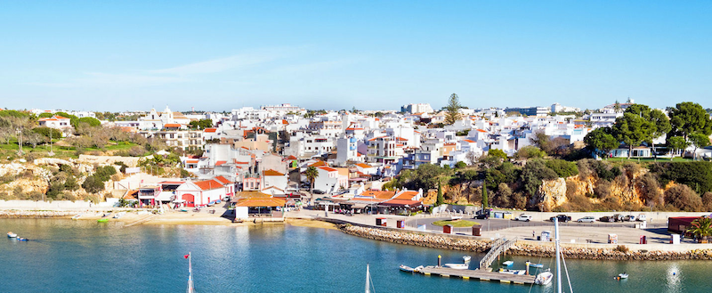
Alvor
Alvor is one of the oldest and most beautiful villages in the Algarve and is another place you won't want to miss when visiting this region! Linked for a long time to the fishing activity, Alvor knew how to keep up with the evolution of the times and currently a large part of its economy is dependent on the tourism industry. In this village, you will discover some places such as the Igreja da Misericórdia, the municipal market and the mouth of the Ria de Alvor where you can admire birds of different species that have chosen this place to nest and beyond. One of the places that stand out in this village is the large Praia de Alvor where you can relax and enjoy the warm weather or take a 5 km walk on what is the longest walkway in the Algarve. Google Maps.: 37.129868, -8.596555
Learn More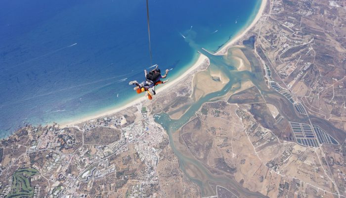
skydive algarve
Skydive Algarve is one of the most fantastic Dropzones to practice skydiving in all of Europe, thanks to the unique landscape of the Algarve Coast. .skydivealgarve.com/ Google Maps.: 37.147869, -8.579847
Learn More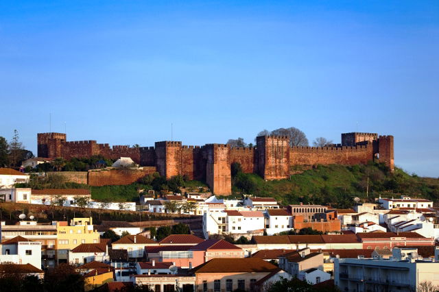
CASTLE DE SILVES
Silves Castle is one of the most remarkable works of military architecture that the Arabs left among us, with more than a thousand years of existence Phone: 282 440 837 email: Castelo@cm-silves.pt Unit price: € 2.80 Combined ticket Castle and Municipal Museum of Archeology: €3.90 Georeferencing: Latitude: 37°11'26.78"N | Longitude: 8°26'16.89"W
SEE OF SILVES
It is considered one of the most notable temples of Gothic architecture in the Algarve. It was probably ordered to be erected at the end of the 13th century, after the definitive conquest of the city, in 1248 or 49, by D. Paio Peres Correia. The Cathedral of Silves presents us with a Gothic style, distorted by the successive reconstructions and restorations to which it was voted. Built in red sandstone (Grés de Silves), the cathedral has a Latin cross plan and comprises an apse and a transept. With a height of approximately 18m, the central nave is higher than the two sides. Hours: Monday to Friday 9:00 am - 5:00 pm Closed on weekends and holidays Google Maps.: 37.189913, -8.438870
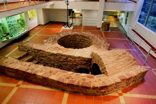
MUNICIPAL MUSEUM OF ARCHEOLOGY OF SILVES
Inaugurated in 1990, the Silves Municipal Museum of Archeology was built around the admirable Well-Cisterna Almóada from the 12th-13th centuries – discovered after archaeological excavations carried out in the 1980s. XX and today classified as a National Monument Opening hours: every day 10:00 am - 6:00 pm (last entry: 5:30 pm) Google Maps.: 37.189013, -8.438904
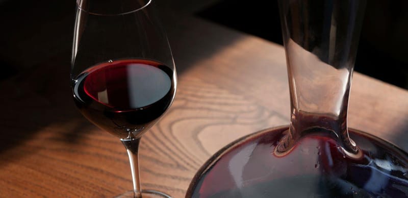
ITINERARY " ITINERARY WINES OF SILVES "
The municipality of Silves is already the municipality that concentrates the largest number of producers in the region, all of them with high-level wines and appealing brands, which have earned the recognition of specialists in international competitions and blind tastings.
Learn More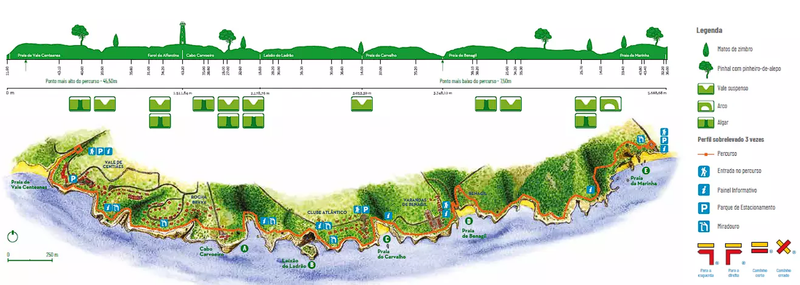
Route of the 7 Hanging Valleys
We challenge you to walk the trails of the Route of the 7 Suspension Valleys, a pedestrian Nature route that extends for 5.7 km, connecting Praia de Vale Centeanes to Praia da Marinha. How to get to the main entrances of the Praia de Vale Centeanes route – Access by road from the lower area of Carvoeiro, heading east for about 2 km; GPS: 37.091695,-8.453938 Praia da Marinha – Access by road from the EN 125, turning south next to Escola Internacional do Algarve and following the signs for the beach; GPS: 37.090193,-8.412986
Fortaleza N. Sra. da Rocha
On the promontory of Senhora da Rocha, a place of worship for Visigoths and Muslims, a fortress was built with a polygonal bastioned wall defended by a moat and drawbridge. The dominant location over the sea, on a rocky spur that is now quite eroded, offered exceptional conditions to defend the populations from the frequent attacks of corsairs without having to erect solid buildings, which is why the earthquake of 1755 completely destroyed it and spared only the chapel of the century XVI. How to reach Mrs. da Rocha, Porches GPS:37.096640, -8.386765
Carvoeiro Walkway, Algar Seco and Pedra da Boneca
The Passadiço do Carvoeiro would be the equivalent of the continuation of the Route of the Seven Hanging Cliffs, which is interrupted between Praia do Vale Centeanes and Algar Seco. It's a very quiet trail, all paved in wood, which lasts less than 1 hour in total, if you don't make stops (which is impossible). Algar Seco is at the beginning of the route and is one of the most beautiful areas in the region. It has natural pools of blue water in the midst of caves and grottoes carved by the wind and sea over millions of years. During high tide, it is worth going for a swim in the main pool. Further ahead is the famous Pedra da Boneca. It is a rock on the cliff that, from the sea, appears to be shaped like a doll. A tunnel crosses the stone, allowing you to walk through the interior halls to the perfectly carved “windows” that allow you to have the most wonderful views. A Boneca is next to a very nice restaurant for those looking for a place to have lunch along the way. Continuing the trail towards Carvoeiro, you will also pass by the Fort of Nossa Senhora da Encarnação, built in the 17th century. The sunsets there are spectacular. From there, tourists will be just a step away from Praia do Carvoeiro. It's just down the street. Google Maps.: 37.093520, -8.465881 Algar Seco
Learn More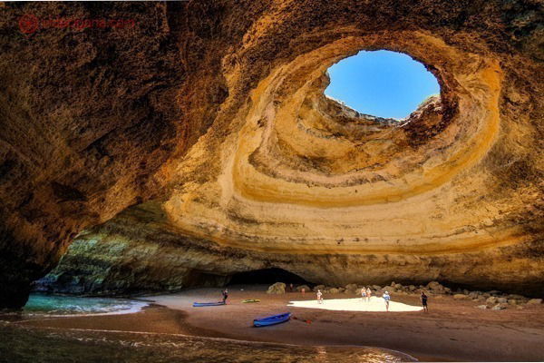
Tour to Benagil Cave
The Benagil Cave is the most anticipated visit for anyone planning a tour of the Algarve. It is a natural cave in the cliffs and can only be accessed from the sea. At the top of the cave there is an entrance through which you can see the sky (it would be a natural Pantheon, I wonder…). To get to the cave, you need to book one of the boat tours that leave from Carvoeiro or Praia de Benagil. It is also possible to rent a kayak, SUP or even swim (for those who have very resistant lungs). Google Maps.: 37.087391, -8.425716
Learn More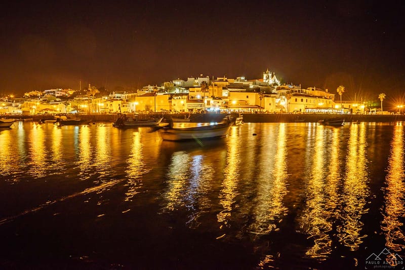
ferragudo
It is one of the few fishing villages to have escaped the mass tourism that has spoiled much of the south coast of Portugal and, in our opinion, is one of the most beautiful in the Algarve. The best of Ferragudo? Walk through the flowery alleys to the church, from where you can see the river Arade and the fort from which the coast was guarded against pirate attacks. Google Maps.: 37.125173, -8.518726
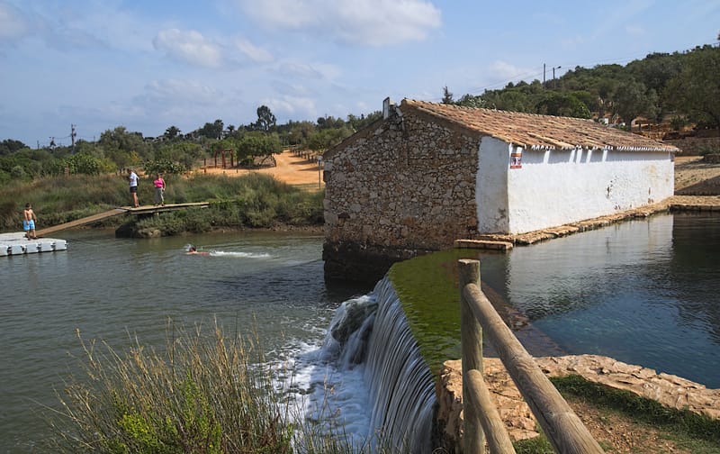
Sítio das Fontes - Municipal Park
Sítio das Fontes is located in the Western Algarve, about 2 km from the village of Estombar, in the municipality of Lagoa. The Park covers an area of around 18ha, around the initial section of a creek on the left bank of the River Arade. The toponym “Sítio das Fontes” is due to the presence of numerous springs originating from the highest water table in the Algarve, known as Querença-Silves, or Lias-Dodger according to geologists. How to get there Take the A22 or N125/IC4 exit at Lagoa, in this town head towards Estômbar and, from there, follow the existing signs. GPS: 37.161437,-8.485105
Learn More
Caldas de Monchique
Caldas de Monchique, also known as Termas de Monchique, is a town and spa located in the parish of Monchique in the municipality of Monchique, in the Algarve region of Portugal. It is located south of the village of Monchique, about 6 km away, next to the EN266 national road. The therapeutic properties of local waters have been recognized since the time of the Roman Empire, when they received the designation of sacred waters. The waters come from eight springs, being rich in bicarbonate, fluorine, silica and sodium. They are suitable for the treatment of problems in the respiratory and digestive systems, as well as for the treatment of muscular and rheumatic problems. They also have relaxing properties. These waters flow at temperatures between 27°C and 31.5°C, possibly due to different flow paths. Google Maps.: 37.286004, -8.553989
Learn More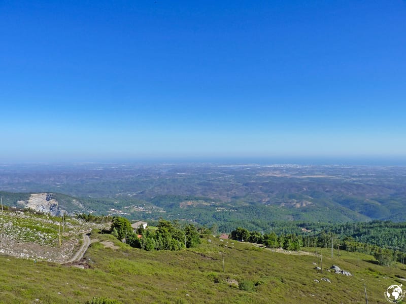
Fóia de Monchique
In Fóia, the horizon opens up in all directions, making it possible to see the Vicentine coast, the mountains to the north and the succession of hills and valleys that descend to the south coast. The view extends along the coast to the Arade estuary, to the east, and to Ponta da Piedade, to the west. In this stony environment with small bushes, some small passerines such as the blackberry owl, the linnet or the cia can be easily observed. Google Maps.: 37.315678, -8.592687
Monchique
Monchique deserves to be visited on foot. Because to appreciate its charms you have to go up and down the streets, peek at vast horizons among the houses, discover small corners of light and tranquility. In the end, the memory of a mountain village with history and character remains, to which you want to return. Google Maps.: 37.318024, -8.556396
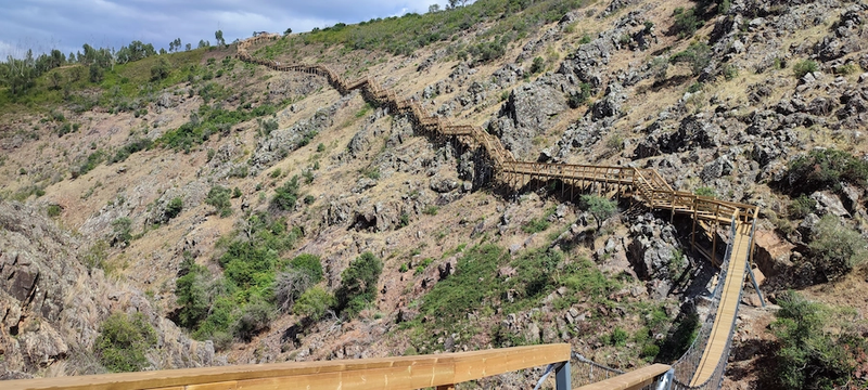
Barranco do Demo walkway
The Barranco do Demo Walkway provides an adventure tour located in the village of Alferce, next to Monchique in the Algarve. The walkway has a suspension bridge that crosses Barranco do Demo, a deep and rocky gorge. We heard about this walkway very recently and went to discover it. The small walkway is part of a walking trail of almost 8 km through the corners of the Monchique mountains. However, you can choose to just visit the walkway and it is a great way to experience the natural beauty of the Algarve and enjoy a small dose of adrenaline. The Barranco do Demo Walkway, being an outdoor and unsupervised attraction, is obviously open all year round. However, knowing the climate of the Monchique mountains, we suggest the best time to visit during spring or autumn, when the climate is milder. Here are some tips to make the most of your walk on the Passadiço do Barranco do Demo: Wear comfortable and appropriate shoes for walking. Bring water and a snack. Don't go alone. Be careful with children. Enjoy the view! Google Maps Location: 37.330265, -8.486748
Learn More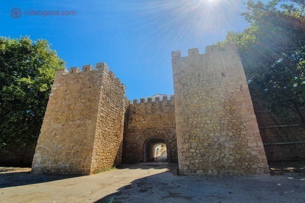
Historic Center of Lagos
O Centro Histórico de Lagos é muito antigo, de quando a cidade ainda se chamava Lacóbriga pelos celtas. Já foi a capital do Reino do Algarve, que só mudou para Faro (que se mantém até os dias atuais) por causa do tsunami que arrasou a cidade em 1755. Bem ali no Centro Histórico ficam as muralhas medievais do antigo Castelo de Lagos. Viradas para o mar, elas defendiam o antigo burgo que ali dentro existia. Uma das portas (a chamada Porta de São Gonçalo, local onde o beato nasceu) está intacta, mesmo após o terremoto de 1755. Bem ali ao lado fica a Igreja de Santa Maria de Lagos, construída no século XV. E um pouco mais adentro da cidade fica a Igreja de Santo Antônio, um dos monumentos mais importantes da região. O interior da igreja é belíssimo, coberto de murais em azulejos e paredes de ouro roubados do Brasil durante as grandes navegações. Vale a visita. Junto ao mar fica a estrutura do século XVII mais bem preservada do Algarve, o Forte da Ponta da Bandeira. A edificação fica no caminho entre a famosa Marina de Lagos e as lindas praias da região. Em seu interior fica a capela de Santa Bárbara, forrada inteiramente em azulejos seiscentistas. Por último, mas não menos importante, o antigo prédio do Mercado de Escravos, o primeiro no mundo a comercializar seres humanos vindos do continente africano, a partir do século XV, o que tornou a cidade de Lagos uma das mais “prósperas” da região. Hoje é um museu chamado Núcleo do Mercado de Escravos e faz parte da Rota da Escravatura da UNESCO. Google Maps.: 37.023440, -8.995474
Learn More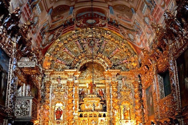
Santo António Church and Lagos Museum
The simple façade of this church hides a very rich interior, where you can admire one of the best examples of gilded carving in Portugal, Baroque tile panels and a beautiful painted ceiling. The old sacristy is occupied by a museum dedicated to the art and culture of Lagos, with a collection of pieces that go back thousands of years (from monoliths to Roman mosaics and tiles) and tell the history of the city from the Celts and Phoenicians to the 17th century. XX. Google Maps.: 37.099399, -8.671306
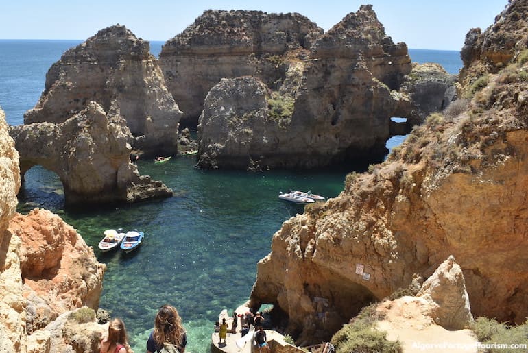
Ponta da Piedade and Lagos Coast
The Ponta da Piedade headland is one of the most beautiful places in Portugal and also one of the most photographed. Its caves and rock formations (some around 20 meters high), carved over thousands of years by the force of the sea and wind, can be best admired on boat trips or kayaking, although there is a long staircase with 182 steps that also offer access down to the water level. From here, you have a breathtaking view of the entire coastline of Lagos and beyond, all the way to Sagres. A short distance away are several magnificent beaches, the closest being Pinheiros, a secret where naturism is common. Then there is the beautiful Praia do Camilo, which is perhaps the most popular for selfies, and Praia da Dona Ana, one of the most famous in the Algarve, also characterized by golden rock formations and beautiful panoramic views. Google Maps.: 37.080976, -8.669538
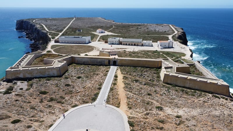
SAGRES FORTRESS
The Fortress of Sagres is the main attraction of the village, and is even the most visited monument in the Algarve. It was classified European Heritage by the European Commission, due to the important role it is believed to have played in the era of the great navigations and in the history of Europe. Although it was built (in 1453) to protect the south coast of Portugal, it turned out to be a place of inspiration for Infante D. Henrique, who imagined discovering new sea routes here. The Infante's vision ended up launching a new era of ocean exploration, with Christopher Columbus reaching the American continent, Vasco da Gama reaching the East by sea and Fernão de Magalhães circumnavigating the globe. The impressive location of the fortress alone deserves a visit, but the historical significance of the monument makes it a mandatory stop on a trip to the Algarve. Google Maps.: 37.001571, -8.947663
Learn More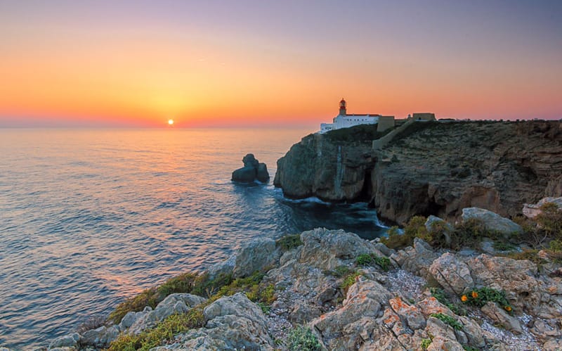
CAPE OF SÃO VICENTE
This is the most southwestern point of Europe, considered the “end of the world” before the Earth was confirmed to be round. It is named São Vicente because it was here that the remains of the saint were found, before being taken to Lisbon in 1173. In 1846 a lighthouse was built with the longest reach in Europe -- around 95 kilometres. This place is visited for its mysticism and wild beauty, with steep cliffs 75 meters high, where the strong waves of the Atlantic break. The sound of the sea, the strong wind and the views are breathtaking. After a visit to the lighthouse, stay to watch the sunset, which is especially magical from here. Cabo de São Vicente is located about six kilometers from the center of the village. Going on foot would take about an hour, but by car it's less than ten minutes. Bus 47 departs from Lagos and ends in the center of Sagres, but three times a day it continues to Cabo de São Vicente. Google Maps.: 37.023440, -8.995474
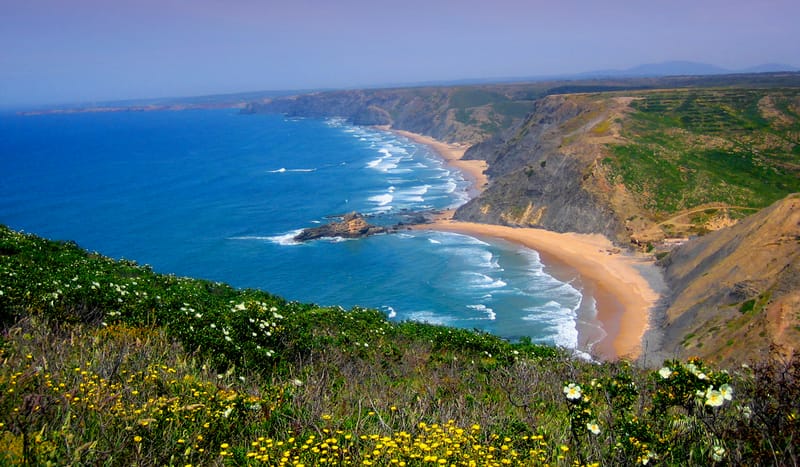
Vincentian Coast
Known as Costa Vicentina, the stretch of coastline between Odeceixe and Burgau is a different Algarve, where the preserved nature has a strong and wild character, which translates into landscapes of dazzling grandeur. This area is part of the Natural Park that begins further north in southwest Alentejo and constitutes the largest stretch of Portuguese coast subject to protection. The beaches follow one another, sometimes with extensive sands as far as the eye can see, or smaller ones framed by grandiose shale and limestone cliffs. The sea, agitated, produces a natural symphony, which serves as the soundtrack for this seaside promenade. We leave from Odeceixe, the most northerly point, a beach that extends on both sides of a stream, providing opportunities for bathing in the sea and river. Around here we find little frequented beaches, some almost deserted with little-known accesses such as Praia das Adegas reserved for the practice of naturism. Vale dos Homens, Carriagem, Amoreira and Monte Clérigo are other beaches to discover between cliffs covered with vegetation, which here and there offer us fabulous panoramas over this rugged coastline. Google Maps.: 37.071873, -8.774727 Burgau Google Maps.: 37.441165, -8.797837 Odeceixe
Learn More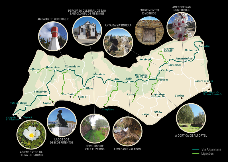
Via Algarviana
The Via Algarviana is the Great Pedestrian Route that takes you to discover the Algarve, from Alcoutim to Cabo de São Vicente, on foot or by bicycle. But there's more. Also explore the additional offer of the route network: 15 Short Routes, 10 Audio Guided Routes, 11 Connections and 4 Thematic Routes. Let yourself be surprised and discover the Via Algarviana. Google Maps.: 37.023440, -8.995474
Learn More